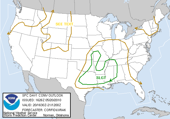
Picture brought to you Storm Prediction Center: http://www.spc.noaa.gov/products/outlook/day1otlk.html
Today: High of 86 with scattered afternoon thunderstorms. SEVERE THUNDERSTORM WATCH IN EFFECT UNTIL 7:00 p.m. Heavy rainfall and strong winds are the main threats. Stay tuned to your local weather news for any new updates. Be sure to get easily damaged items indoors such as small pots or flowers due to strong winds.
Tonight: Low of 67; lingering showers throughout the night
~Starkville, MS
Currently
Good afternoon to everyone and I hope all is well with you. Conditions currently are a bit on the muggy side with temperatures in the upper 70s with dewpoint near 70. Yep, something has to brewing up right? Well, we do have some stormy weather heading our way in the next few hours.
What's Happening Atmospherically
A stormy afternoon is in store for in the next few hours as the National Weather Service has issued a Severe Thunderstorm Watch for mostly the northern and central MS counties and Oktibbeha is included in this watch. The Storm Prediction Center has us also in the slight risk area for severe weather. The NWS has issued the watch and it will be in effect until about 7:00 p.m. The reason for this watch is due to a strong potent system pushing its way through. Already, we have storms firing up in portions of AR and the western edge of the MS delta region. According to the latest model run, we have a low which is negatively tilted located in Kansas right now. The low, however, is moving in a northerly motion which will not really allow for us to see any real main threat from this system. When I say main threat I mean possible chance of seeing a tornado. We will see scattered thunderstorms in the area with winds gusting up 70mph. Winds can certainly caused alot of damage when speeds are that high. Also, the possibility of a tornado in some areas cannot be ruled out either. Certainly, today we will see heavy rainfall here but our southern counties will miss out on the brunt of this system. Mostly, they will see isolated thunderstorms. The pieces are mostly together for severe weather as by looking at 300 mb, I am seeing some divergence and rising air being in the favorable part of the jet streak. So, some good strong upper level winds. Small bits of PVA (positive vorticity advection) in the area, but not much. Also, some very good warm air advection in place looking at 850mb. So, the elements and I certainly can't rule out possible tornado. The main thing to worry about is the heavy rain and winds. I'll keep you all updated if any severe threat becomes apparent. Today, the warm sector or warm front will give us this rain, as the cold front which will drag behind gives us another round of showers Friday.
A stormy afternoon is in store for in the next few hours as the National Weather Service has issued a Severe Thunderstorm Watch for mostly the northern and central MS counties and Oktibbeha is included in this watch. The Storm Prediction Center has us also in the slight risk area for severe weather. The NWS has issued the watch and it will be in effect until about 7:00 p.m. The reason for this watch is due to a strong potent system pushing its way through. Already, we have storms firing up in portions of AR and the western edge of the MS delta region. According to the latest model run, we have a low which is negatively tilted located in Kansas right now. The low, however, is moving in a northerly motion which will not really allow for us to see any real main threat from this system. When I say main threat I mean possible chance of seeing a tornado. We will see scattered thunderstorms in the area with winds gusting up 70mph. Winds can certainly caused alot of damage when speeds are that high. Also, the possibility of a tornado in some areas cannot be ruled out either. Certainly, today we will see heavy rainfall here but our southern counties will miss out on the brunt of this system. Mostly, they will see isolated thunderstorms. The pieces are mostly together for severe weather as by looking at 300 mb, I am seeing some divergence and rising air being in the favorable part of the jet streak. So, some good strong upper level winds. Small bits of PVA (positive vorticity advection) in the area, but not much. Also, some very good warm air advection in place looking at 850mb. So, the elements and I certainly can't rule out possible tornado. The main thing to worry about is the heavy rain and winds. I'll keep you all updated if any severe threat becomes apparent. Today, the warm sector or warm front will give us this rain, as the cold front which will drag behind gives us another round of showers Friday.
Today
Expect for scattered thunderstorms throughout the afternoon hours with heavy winds associated with a low pressure system. Lingering showers throughout the night hours.
Expect for scattered thunderstorms throughout the afternoon hours with heavy winds associated with a low pressure system. Lingering showers throughout the night hours.
Friday outlook
Rain still in our forecast tomorrow as that cold front finally drags down. After it moves out, it looks like conditions clears back out for us this weekend. Be sure to always give God the glory whether its sunny or stormy outside! God bless!
Rain still in our forecast tomorrow as that cold front finally drags down. After it moves out, it looks like conditions clears back out for us this weekend. Be sure to always give God the glory whether its sunny or stormy outside! God bless!


No comments:
Post a Comment