Monday, January 31, 2011
Interesting day tomorrow
Possible Severe tomorrow. Stay tuned for a full report early Tuesday morning here at your Face of the Sky forecast!
Monday's forecast for January 31, 2011
Today's forecast:
Jackson, MS-------High 65 Low 56
Starkville, MS-----High 61 Low 52
Meridian, MS------High 63 Low 56
Vicksburg, MS-----High 63 Low 54
Greenwood, MS----High 63 Low 54
Tupelo, MS--------High 63 Low 52
Hattiesburg, MS---High 70 Low 56
Pascagoula, MS----High 70 Low 58
~Jackson, MS
Currently~as of 9:40a.m.
A good Monday to you all and I hope everyone had great weekend. As far as weather goes for last Friday and Saturday, spring-like weather was the highlight. It was absolutely fantastic Saturday as highs were in the 70s. Conditions quickly change Sunday as rain moved on and made for a wet day throughout Sunday afternoon. Right now, most of the showers has moved off of the area but we are still under heavy cloud conditions. Temperatures are still going to stay pretty for today and we will end the last day of January on a mild note. However, we could possibly start the month of February with severe weather.
Tuesday and Wednesday outlook
Severe storms and heavy rainfall are likely to affect the start of February. Models are in good agreement of displacing a low pressure system across the southern region for Tuesday and into Tuesday night. Now, this surface low is going to be in western portion of Texas early Tuesday and should deepen as it moves into the southern region. A squall line will form and from that we will have gusty winds tomorrow and because of this a wind advisory will be issued by the NWS later today or tomorrow.
The primary threat tomorrow will be strong and gusty winds but hail and tornadoes are possible. If the right type of conditions mixes, then something is bound to form such as a tornado but as of right now only strong winds and a heavy downpour for tomorrow. The SPC (Storm Prediction Center) has highlighted a small risk area for the southern portion of MS.
After tomorrow, Wednesday will be much cooler as cold air swings back into our area. Tuesday will be an interesting day for sure. I'll have more details coming later today.
Thursday, January 27, 2011
Warming Trend Starts Today
***Don't have time to read my blog?? Well, please check out my weather radio podcast! It's very fast and quick to the point. Hey, and it's only 30secs! I know you have 30 seconds of time in your schedule! To listen to my 30 sec radio podcast, go to the right of the page where it says Weather Radio Podcast. Click on play and there you have it. Also, you might have to pause the music that's playing in the background in order for you to hear it. Just go to the bottom of the page and click pause. Enjoy!***
Today's forecast:
Jackson, MS-------High 58 Low 34
Starkville, MS-----High 54 Low 34
Meridian, MS------High 56 Low 31
Vicksburg, MS-----High 58 Low 36
Greenwood, MS----High 54 Low 34
Tupelo, MS--------High 54 Low 34
Hattiesburg, MS---High 59 Low 34
Pascagoula, MS----High 58 Low 36
~Jackson, MS
Currently~as of 6:15a.m.
A good day to you all and welcome back to your Face of the Sky forecast. As I observe the ground this morning outside my home, lots of frost is on the ground due to below freezing temperatures last night. So, a chilly start for those of you beginning your morning commute to your destinations. Except for a few cirrus clouds, we are mostly clear with calm winds. Don't let this cold start fool you into thinking another cool day. Today, there will be an increase of an 8-10 degree difference in our highs compared to yesterday's which will kick off our warming trend.
What's Happening Atmospherically
It is not very active here in the south right now with the majority of precipitation in the northeast. Now, most of that precipitation has been turned into snow for that region dumping heavy amounts of snow into a region already deeply impacted by winter weather. In Philadelphia, Pa the area has already received up to 14" of snow. There are several reports of thunder snow and 2-3" per rates right now. Some areas in New York City are already up to a foot of snow and could very well end up between 16-18". Incredible to say the least! Imagine snow amounts like that here!
Right now, northerly flow aloft is going to be farther north allowing for high pressure to really take control of th e weather in the south and will be the primary reason for our warming trend. Like I stated yesterday, instead of our northerly flow we will have more of a zonal and westerly low level flow which in term will warm us up a bit considering we won't have to deal with cold air from the north. It also has to do with La Nina being in its peak allowing for warmer temperatures in the winter here.
So as this high pressure moves farther east, it will give us more of a southeasterly flow which will help increase temperatures through the weekend. Saturday we will be all the way into the mid 60s. Talk about your early preview of spring!
Of course, spring weather and conditions will not make an entrance as next week looks to prove that. We could be hit with another blast of cold air early next week. As far as our next chance of rain, the GFS model has a short wave advancing to our area by Sunday. This system looks to bring in some afternoon showers for Sunday afternoon and night.
Today
Second consecutive day of sunny skies in the forecast with maybe a few high clouds hovering around. It will only add to the beauty of today as highs will be much warmer today. Highs are going to be in the upper 50s with winds west at 10 to 15mph. This could make conditions feel a little cool.
Tonight
Great night to watch some stars tonight as we will have a mostly clear night. Lows will be in the mid to lower 30s throughout the Mississippi region with southwest winds at 5-10 mph.
Friday's outlook
We will not deviate from our pattern of warmer weather as the start of our weekend looks again to be sunny and warmer. This will be a great start to the weekend with Saturday looking to be the nicest day of the week. Chance of showers for Sunday afternoon.
If you have any plans this weekend, I would say go ahead with them because lovely weather will set us up very nicely. This has been your Face of the Sky forecast! Have a relaxing day and God bless!
Today's forecast:
Jackson, MS-------High 58 Low 34
Starkville, MS-----High 54 Low 34
Meridian, MS------High 56 Low 31
Vicksburg, MS-----High 58 Low 36
Greenwood, MS----High 54 Low 34
Tupelo, MS--------High 54 Low 34
Hattiesburg, MS---High 59 Low 34
Pascagoula, MS----High 58 Low 36
~Jackson, MS
Currently~as of 6:15a.m.
A good day to you all and welcome back to your Face of the Sky forecast. As I observe the ground this morning outside my home, lots of frost is on the ground due to below freezing temperatures last night. So, a chilly start for those of you beginning your morning commute to your destinations. Except for a few cirrus clouds, we are mostly clear with calm winds. Don't let this cold start fool you into thinking another cool day. Today, there will be an increase of an 8-10 degree difference in our highs compared to yesterday's which will kick off our warming trend.
What's Happening Atmospherically
It is not very active here in the south right now with the majority of precipitation in the northeast. Now, most of that precipitation has been turned into snow for that region dumping heavy amounts of snow into a region already deeply impacted by winter weather. In Philadelphia, Pa the area has already received up to 14" of snow. There are several reports of thunder snow and 2-3" per rates right now. Some areas in New York City are already up to a foot of snow and could very well end up between 16-18". Incredible to say the least! Imagine snow amounts like that here!
Right now, northerly flow aloft is going to be farther north allowing for high pressure to really take control of th
 e weather in the south and will be the primary reason for our warming trend. Like I stated yesterday, instead of our northerly flow we will have more of a zonal and westerly low level flow which in term will warm us up a bit considering we won't have to deal with cold air from the north. It also has to do with La Nina being in its peak allowing for warmer temperatures in the winter here.
So as this high pressure moves farther east, it will give us more of a southeasterly flow which will help increase temperatures through the weekend. Saturday we will be all the way into the mid 60s. Talk about your early preview of spring!
Of course, spring weather and conditions will not make an entrance as next week looks to prove that. We could be hit with another blast of cold air early next week. As far as our next chance of rain, the GFS model has a short wave advancing to our area by Sunday. This system looks to bring in some afternoon showers for Sunday afternoon and night.
Today

Second consecutive day of sunny skies in the forecast with maybe a few high clouds hovering around. It will only add to the beauty of today as highs will be much warmer today. Highs are going to be in the upper 50s with winds west at 10 to 15mph. This could make conditions feel a little cool.
Tonight
Great night to watch some stars tonight as we will have a mostly clear night. Lows will be in the mid to lower 30s throughout the Mississippi region with southwest winds at 5-10 mph.
Friday's outlook
We will not deviate from our pattern of warmer weather as the start of our weekend looks again to be sunny and warmer. This will be a great start to the weekend with Saturday looking to be the nicest day of the week. Chance of showers for Sunday afternoon.
If you have any plans this weekend, I would say go ahead with them because lovely weather will set us up very nicely. This has been your Face of the Sky forecast! Have a relaxing day and God bless!
Wednesday, January 26, 2011
Wednesday's forecast for January 26, 2011
***Don't have time to read my blog?? Well, please check out my weather radio podcast! It's very fast and quick to the point. Hey, and it's only 30secs! I know you have 30 seconds of time in your schedule! To listen to my 30 sec radio podcast, go to the right of the page where it says Weather Radio Podcast. Click on play and there you have it. Also, you might have to pause the music that's playing in the background in order for you to hear it. Just go to the bottom of the page and click pause. Enjoy!***
Today's forecast:
Jackson, MS-------High 50 Low 31
Starkville, MS-----High 47 Low 29
Meridian, MS------High 49 Low 27
Vicksburg, MS-----High 49 Low 29
Greenwood, MS----High 47 Low 29
Tupelo, MS--------High 45 Low 27
Hattiesburg, MS---High 54 Low 29
Pascagoula, MS----High 56 Low 31
~Jackson, MS
Currently~as of 6:20a.m.
A good Wednesday to you all and thanks for stopping by to view your Face of the Sky forecast today. By now, we are comp letely done with this upper level low which brought in some much needed rain for the region. It was also speculated that this system would probably perhaps bring in some snow for some areas here in MS. It didn't quite live up to its forecast as this system moved farther north than expected, therefore, displacing moisture farther north as well. Now, I do have reports that around the Memphis area they receive a close to inch in the amount of snow. As you start to make your way south of the city into Mississippi, conditions were free from snow although temperatures got pretty low around the state. Even though we are finished with this upper level low, the northeast and coastal areas of the U.S. will deal heavily with it as this (winter storm) will produce heavy snowfall within the region.
Currently, we are sitting in the lower 30s with winds out the west at 5 mph. There is wrap around cloud cover this morning for the northern portion of MS, but will soon move off. Although sunny for today, you will still need to bundle up tightly because it is going to be cold.
What's Happening Atmospherically
To close out the very few days left in January, we will be relatively quiet in terms of precipitation. As I mentioned a little earlier, this upper level system will travel northeasterly becoming a winter storm producing large amounts of snow for the northeast and along the coast. Some areas could receive more than 8 inches! How about driving in that here in Mississippi! Now, right behind this low will follow a weak high pressure which will be the primary reason for the few clouds but mostly sunny conditions today. Even with this high pressure located in the southeast Texas, weather conditions will be on the cool side of things. At 850mb, a fair amount of cold air advection will pour into the southern region and we will continue to get this cold blast of air throughout most of the day. It is not very much but will still keep temperatures cool throughout the day.

After today, we will begin a warming trend. As 850mb depicts, by Thursday we should start to have a more westerly flow in our weather pattern instead of our usual flow from the north. This trough that we have become accustomed to during this winter season that has brought cold conditions into the region, will level off a bit giving us a more zonal pattern. So, we won't have to endured the cold air from the north much as winds will start to come out from the west and south and will be a cause of our warming trend. High pressure will continue to move across the south and we could see temperatures close to the 60s tomorrow. By Saturday, temperatures could be as high as 65 degrees. All of this will be accompany by mostly sunny conditions. Even though rain is needed throughout the southeast, we could very well end the last days of January on a dry note.
 Today
Today
You don't have to deal with cloudy and gray conditions today as we will have ample amount of sunshine today. We may have some stray clouds, but other than that just clear and beautiful conditions. However, cool temperatures will make you have to bundle up tightly in your coats with temperatures in the upper 40s in Jackson and elsewhere besides the coast which will feature highs in the 50s. Northwest winds at 5 to 10 mph will make conditions here even colder.

Tonight
Snuggling under a blanket by a fireplace would be the perfect place to be situated at especially during a cold night like tonight. Expecting temperatures to once again plummet down into the lower 30s. Wind chill factor in the upper 20s especially with winds at 5 mph from the northwest. May have some clouds tonight, but will clear out by Thursday morning.
Thursday's outlook
Another day full of sunshine as temperatures will be a little warmer. Look for upper 50s for highs tomorrow.
Thanks again for dropping by to look at your Face of the Sky forecast. If you have any comments or anything you would like to say, please post them. Have a great day and may God bless all of you!
Today's forecast:
Jackson, MS-------High 50 Low 31
Starkville, MS-----High 47 Low 29
Meridian, MS------High 49 Low 27
Vicksburg, MS-----High 49 Low 29
Greenwood, MS----High 47 Low 29
Tupelo, MS--------High 45 Low 27
Hattiesburg, MS---High 54 Low 29
Pascagoula, MS----High 56 Low 31
~Jackson, MS
Currently~as of 6:20a.m.
A good Wednesday to you all and thanks for stopping by to view your Face of the Sky forecast today. By now, we are comp
 letely done with this upper level low which brought in some much needed rain for the region. It was also speculated that this system would probably perhaps bring in some snow for some areas here in MS. It didn't quite live up to its forecast as this system moved farther north than expected, therefore, displacing moisture farther north as well. Now, I do have reports that around the Memphis area they receive a close to inch in the amount of snow. As you start to make your way south of the city into Mississippi, conditions were free from snow although temperatures got pretty low around the state. Even though we are finished with this upper level low, the northeast and coastal areas of the U.S. will deal heavily with it as this (winter storm) will produce heavy snowfall within the region.
Currently, we are sitting in the lower 30s with winds out the west at 5 mph. There is wrap around cloud cover this morning for the northern portion of MS, but will soon move off. Although sunny for today, you will still need to bundle up tightly because it is going to be cold.
What's Happening Atmospherically
To close out the very few days left in January, we will be relatively quiet in terms of precipitation. As I mentioned a little earlier, this upper level system will travel northeasterly becoming a winter storm producing large amounts of snow for the northeast and along the coast. Some areas could receive more than 8 inches! How about driving in that here in Mississippi! Now, right behind this low will follow a weak high pressure which will be the primary reason for the few clouds but mostly sunny conditions today. Even with this high pressure located in the southeast Texas, weather conditions will be on the cool side of things. At 850mb, a fair amount of cold air advection will pour into the southern region and we will continue to get this cold blast of air throughout most of the day. It is not very much but will still keep temperatures cool throughout the day.

After today, we will begin a warming trend. As 850mb depicts, by Thursday we should start to have a more westerly flow in our weather pattern instead of our usual flow from the north. This trough that we have become accustomed to during this winter season that has brought cold conditions into the region, will level off a bit giving us a more zonal pattern. So, we won't have to endured the cold air from the north much as winds will start to come out from the west and south and will be a cause of our warming trend. High pressure will continue to move across the south and we could see temperatures close to the 60s tomorrow. By Saturday, temperatures could be as high as 65 degrees. All of this will be accompany by mostly sunny conditions. Even though rain is needed throughout the southeast, we could very well end the last days of January on a dry note.
 Today
TodayYou don't have to deal with cloudy and gray conditions today as we will have ample amount of sunshine today. We may have some stray clouds, but other than that just clear and beautiful conditions. However, cool temperatures will make you have to bundle up tightly in your coats with temperatures in the upper 40s in Jackson and elsewhere besides the coast which will feature highs in the 50s. Northwest winds at 5 to 10 mph will make conditions here even colder.

Tonight
Snuggling under a blanket by a fireplace would be the perfect place to be situated at especially during a cold night like tonight. Expecting temperatures to once again plummet down into the lower 30s. Wind chill factor in the upper 20s especially with winds at 5 mph from the northwest. May have some clouds tonight, but will clear out by Thursday morning.
Thursday's outlook
Another day full of sunshine as temperatures will be a little warmer. Look for upper 50s for highs tomorrow.
Thanks again for dropping by to look at your Face of the Sky forecast. If you have any comments or anything you would like to say, please post them. Have a great day and may God bless all of you!
Tuesday, January 25, 2011
Tuesday's forecast for January 25, 2011
***Don't have time to read my blog?? Well, please check out my weather radio podcast! It's very fast and quick to the point. Hey, and it's only 30secs! I know you have 30 seconds of time in your schedule! To listen to my 30 sec radio podcast, go to the right of the page where it says Weather Radio Podcast. Click on play and there you have it. Also, you might have to pause the music that's playing in the background in order for you to hear it. Just go to the bottom of the page and click pause. Enjoy!***
Today's forecast:
Jackson, MS-------High 53 Low 35
Starkville, MS-----High 47 Low 34
Meridian, MS------High 52 Low 36
Vicksburg, MS-----High 49 Low 32
Greenwood, MS----High 47 Low 31
Tupelo, MS--------High 45 Low 31
Hattiesburg, MS---High 56 Low 36
Pascagoula, MS----High 65 Low 40
~Jackson, MS
Currently~as of 6:45a.m.
A wet and rainy start to your Tuesday morning. It has rain for nearly the whole period of Tuesday morning and we have receive alot of it. We have already received just under an inch of rain here alone in the Jackson area. At this current moment, most of the northern counties are still under heavy rainfall while a little portion of the southeast have started to slack off from it. Low temperatures did not fall very much last night due to heavy c loud cover. Actually, our temperatures will be decreasing slowly today and so we will already have had our high for today which occurred sometime overnight. Nearly close to an inch of rain in rainfall total, yet we are not quite done yet for the day.
What's Happening Atmospherically
The upper level low which is the cause for the current weather conditions is moving slowly but due northeast. Like I stated previously we have received much precipitation and much more is expected today.QPF (Quantitative Precipitation Forecasts) forecasts about a half an inch of rain still to fall today and even more in the northern half of Mississippi. According to Short Range Forecast, by 00z (7:00p.m.) the upper level low should be in the lower half of Alabama. So, by then some of the rain will have departed from south MS. Also, the Jackson area and everything below Interstate 20 will start to decrease in rain as well. By then we will be in the dry slot behind this upper level low and this will also help to explain declining temperatures as I stated earlier.
Close to midnight we were at 53 degrees and like normal your temperatures drop due to the surface losing heat and cooling. Also, like normal as the sun rises temperatures rises as well but we'll see an opposite effect as temperatures decline steadly throughout the afternoon due to cold air behind this upper level low which will help to lower temperatures especially here in Jackson. You also have other factors such as cloud cover for most of the day limited increase. Now, along the coast temperatures will stay warm and even rise into the 60s due to the warm air off the coast. For areas farther out from the coast though, we will have declining temperatures today. Again this will be overshadowed due to rain for most of the day.
By late this evening a nd into tonight, rain should start to push off from central Mississippi leaving the northern half of Mississippi with persisting rain. Since the northern half will still have some moisture, there is a possibility of rain mixing to snow late Tuesday night. The very northern portion of Mississipi will have a better chance of snow than any other area in Mississippi. It includes areas anywhere from Tupelo and up. The farther down you are in Mississippi, chances and possibility decrease drastically. Temperatures will cool especially at higher levels in the atmosphere. However, even with the changeover I'm not looking for any accumulations to occur in Jackson. Chances for snow is very limited and if it does happen it will occur for a short period before daybreak on Wednesday. If snow chances increase, I'll be sure to update.
By Wednesday, this upper level low will completely have made its way out of our region with high pressure moving back into the forecast. Though we've alread y receive alot of rain this morning, we are still in the midst of a drought. The reason for this is because La Nina has kept storms and most of their precipitation in the north, leaving the South drier than normal. La Nina is defined as unusually cold ocean temperatures in the Pacific compared to El Nino which is the opposite. Its relevance here is that it keeps our winter warmer than normal and has kept us drier than normal by having most of rainfall occur up north. The places that have been affected the hardest are Texas and Florida. So, that is why the rain we are getting now is so important even though it may seemed a little much.
Today
Still lots of rain to fall with an amount close to under half an inch to fall today. Rain will slowly get lighter by then end of the afternoon. Temperatures will hover around the 40s in Jackson for the most part and decline through the afternoon. Weather conditions won't change much as we will continue to be under cloudy gray skies with winds out of the northwest at 10 mph.
Tonight
The bulk of the r ain will have cleared away for us leaving only the northern half to contend with lingering showers. Chances of mixing snow here is very slim with surface lows being too warm to have any snow stick to the ground especially here in Jackson. Top northern of MS could see possible snow sticking to the ground with a greater better of snow the further you head north.
Lows are going to be in the mid to lower 30s. Northwest winds still at 10 mph with cloudy skies clearing out some overnight. Northern half of Mississippi will still be under alot of cloud cover.
Wednesday's outlook
We will start the day off bright and sunny with clear conditions. Temperatures will struggle to rise with cold air in place. We'll mostly stay in the 40s once again, but after Wednesday temperatures will continue to increase throughout the week.
I'll tell you more about this warming trend tomorrow. Thanks for stopping by to view your Face of the Sky forecast. Despite the rain, go out and enjoy the day for this is the day that the Lord has made! God bless!
Today's forecast:
Jackson, MS-------High 53 Low 35
Starkville, MS-----High 47 Low 34
Meridian, MS------High 52 Low 36
Vicksburg, MS-----High 49 Low 32
Greenwood, MS----High 47 Low 31
Tupelo, MS--------High 45 Low 31
Hattiesburg, MS---High 56 Low 36
Pascagoula, MS----High 65 Low 40
~Jackson, MS
Currently~as of 6:45a.m.
A wet and rainy start to your Tuesday morning. It has rain for nearly the whole period of Tuesday morning and we have receive alot of it. We have already received just under an inch of rain here alone in the Jackson area. At this current moment, most of the northern counties are still under heavy rainfall while a little portion of the southeast have started to slack off from it. Low temperatures did not fall very much last night due to heavy c
 loud cover. Actually, our temperatures will be decreasing slowly today and so we will already have had our high for today which occurred sometime overnight. Nearly close to an inch of rain in rainfall total, yet we are not quite done yet for the day.
What's Happening Atmospherically
The upper level low which is the cause for the current weather conditions is moving slowly but due northeast. Like I stated previously we have received much precipitation and much more is expected today.QPF (Quantitative Precipitation Forecasts) forecasts about a half an inch of rain still to fall today and even more in the northern half of Mississippi. According to Short Range Forecast, by 00z (7:00p.m.) the upper level low should be in the lower half of Alabama. So, by then some of the rain will have departed from south MS. Also, the Jackson area and everything below Interstate 20 will start to decrease in rain as well. By then we will be in the dry slot behind this upper level low and this will also help to explain declining temperatures as I stated earlier.
Close to midnight we were at 53 degrees and like normal your temperatures drop due to the surface losing heat and cooling. Also, like normal as the sun rises temperatures rises as well but we'll see an opposite effect as temperatures decline steadly throughout the afternoon due to cold air behind this upper level low which will help to lower temperatures especially here in Jackson. You also have other factors such as cloud cover for most of the day limited increase. Now, along the coast temperatures will stay warm and even rise into the 60s due to the warm air off the coast. For areas farther out from the coast though, we will have declining temperatures today. Again this will be overshadowed due to rain for most of the day.
By late this evening a
 nd into tonight, rain should start to push off from central Mississippi leaving the northern half of Mississippi with persisting rain. Since the northern half will still have some moisture, there is a possibility of rain mixing to snow late Tuesday night. The very northern portion of Mississipi will have a better chance of snow than any other area in Mississippi. It includes areas anywhere from Tupelo and up. The farther down you are in Mississippi, chances and possibility decrease drastically. Temperatures will cool especially at higher levels in the atmosphere. However, even with the changeover I'm not looking for any accumulations to occur in Jackson. Chances for snow is very limited and if it does happen it will occur for a short period before daybreak on Wednesday. If snow chances increase, I'll be sure to update.
By Wednesday, this upper level low will completely have made its way out of our region with high pressure moving back into the forecast. Though we've alread
 y receive alot of rain this morning, we are still in the midst of a drought. The reason for this is because La Nina has kept storms and most of their precipitation in the north, leaving the South drier than normal. La Nina is defined as unusually cold ocean temperatures in the Pacific compared to El Nino which is the opposite. Its relevance here is that it keeps our winter warmer than normal and has kept us drier than normal by having most of rainfall occur up north. The places that have been affected the hardest are Texas and Florida. So, that is why the rain we are getting now is so important even though it may seemed a little much.
Today
Still lots of rain to fall with an amount close to under half an inch to fall today. Rain will slowly get lighter by then end of the afternoon. Temperatures will hover around the 40s in Jackson for the most part and decline through the afternoon. Weather conditions won't change much as we will continue to be under cloudy gray skies with winds out of the northwest at 10 mph.
Tonight
The bulk of the r
 ain will have cleared away for us leaving only the northern half to contend with lingering showers. Chances of mixing snow here is very slim with surface lows being too warm to have any snow stick to the ground especially here in Jackson. Top northern of MS could see possible snow sticking to the ground with a greater better of snow the further you head north.
Lows are going to be in the mid to lower 30s. Northwest winds still at 10 mph with cloudy skies clearing out some overnight. Northern half of Mississippi will still be under alot of cloud cover.
Wednesday's outlook
We will start the day off bright and sunny with clear conditions. Temperatures will struggle to rise with cold air in place. We'll mostly stay in the 40s once again, but after Wednesday temperatures will continue to increase throughout the week.
I'll tell you more about this warming trend tomorrow. Thanks for stopping by to view your Face of the Sky forecast. Despite the rain, go out and enjoy the day for this is the day that the Lord has made! God bless!
Monday, January 24, 2011
Monday's forecast for January 24, 2011
***Don't have time to read my blog?? Well, please check out my weather radio podcast! It's very fast and quick to the point. Hey, and it's only 30secs! I know you have 30 seconds of time in your schedule! To listen to my 30 sec radio podcast, go to the right of the page where it says Weather Radio Podcast. Click on play and there you have it. Also, you might have to pause the music that's playing in the background in order for you to hear it. Just go to the bottom of the page and click pause. Enjoy!***
Today's forecast:
Jackson, MS-------High 55 Low 45
Starkville, MS-----High 54 Low 38
Meridian, MS------High 58 Low 38
Vicksburg, MS-----High 54 Low 41
Greenwood, MS----High 52 Low 40
Tupelo, MS--------High 52 Low 38
Hattiesburg, MS---High 61 Low 43
Pascagoula, MS----High 61 Low 49
~Jackson, MS
Currently~as of 6:50a.m.
Hi and welcome to your Monday's editon of your Face of the Sky forecast. According to an article on the site of msn, today is considered the most depressing day of the year. According to a British researcher named Dr. Cliff Arnall from Cardiff University, states that this formula for this day is made up of factors such as "post holiday blahs and debt, failed New Year's resolutions, and the nasty chill weather reaching further south than usual." So, today is actually "Blue Monday."
I would say that weather conditions could possibly reverse this "Blue Monday" for you but conditions ahead later in the next couple of hours doesn't look all so great. After enjoying a rather rain-free weekend, the start of our work week will be a wet and gloomy one. Currently this morning we are starting off cloudy with temperatures in the mid 40s.
So, allow me to explain this rainy forecast for you today.
What's Happening Atmospherically
Early this morning and th roughout the early part of the afternoon a weak low level disturbance will move across the region which is going to drag a weak cold front through. From this forcing, we could have some scattered light showers this morning but most of it will be held in the northern counties of MS. Its going to be weak, so not much of an impact in our weather from that system. The main story and the focusing impact of our wet day is going to be made up of two combinations: First, at (500mb levels) we have a strong upper trough coming out of the plains with lots of moisture. Secondly, a gulf low will develop out of the Gulf of Mexico and push toward our area from the southwest. These combine forces along with lifting mechanism will induce widespread and heavy precipitation throughout the entire state of Mississippi and the southern region.
All of this should come well together by late this evening. We'll probably have some light showers in this afternoon but most of the precipitation will fall throughout late evening and into the early morning of Tuesday. Temperatures will stay pretty mild for us with southeast winds. Even by then, showers will continue to fall as this rain shield continue to travel northeast. A rain shield is simply define as a solid area of rain. Early Tuesday morning alone we could possibly see up to 0.50 inch of rain in the Jackson area. Overall, according to QPF (Quantitative Precipitation Forecast) we could have anywere from a half an inch to an inch and a quarter amount of rainfall total. Steady precipitation will persist and will really take its time moving out of the area. Tuesday will be a very wet day with showers occuring for most of the day. This is due to the circulation of the low which is steadly going to draw or place moisture within the MS region.
Due to this circulation, we could have a chance of mixing snow for Tuesday night. However, a tricky forecast because even though moisture will evident in the area, surface temperatures will be too warm in my opinion to accumulate anything. The rain and snow will possibly mix and there is a chance with that especially with temperatures aloft supporting conditions for rain particles to freeze into snow. This will occur mostly in areas north of I-20 and north of the Hwy 82 corridor. Observing Bufkit files, I will say we have a chance of having a mix with much of the layer condusive to snow formation but again the warm surface will prevent any accumulations and the snow will be overshadowed by the rain that's falling. If small amounts of snow does occur, it will quickly come to a halt by daybreak of Wednesday. I'll have more updates for you tomorrow on this. By Wednesday afternoon, models show precipitation finally clearing out of the area.
Today
A rainy start to our week will begin shortly in the afternoon and mainly in the late evening and night hours. Before the rain start, watch for more clouds to move into the Jackson area making for overcast conditions with mild temperatures in the 50s. Southeast winds at 5mph.
Tonight
Get ready to sleep good tonight for those of you who love to sleep during the rain. Good amounts of widespread rainfall will fall steadly through the night with most of the rain falling on early Tuesday morning. There maybe a few rumbling of thunder here and there mostly in the southern counties. The entire state will pretty much experience widespread showers with heavier amounts falling southeast. Temperatures tonight will level off a bit to the 40s with an east wind of 5-10 mph.

Tuesday's outlook
Rain will persist into our Tuesday forecast and will be a wet day for the most part. We could see anywhere from 0.50 to 1.25 easily with the amount of rainfall we'll have. Highs in the mid 40s. A slim chance of snow mixing in for Tuesday night.
Even though we are going to get a good amount of rain, this is actually really needed here in the southern region. Did you know we are in the midst of a drought. If not then I'll tell you all about it in tomorrow's Face of the Forecast. Well, don't let this weather get you down too much today. Have a great Monday and God bless!
Today's forecast:
Jackson, MS-------High 55 Low 45
Starkville, MS-----High 54 Low 38
Meridian, MS------High 58 Low 38
Vicksburg, MS-----High 54 Low 41
Greenwood, MS----High 52 Low 40
Tupelo, MS--------High 52 Low 38
Hattiesburg, MS---High 61 Low 43
Pascagoula, MS----High 61 Low 49
~Jackson, MS
Currently~as of 6:50a.m.
Hi and welcome to your Monday's editon of your Face of the Sky forecast. According to an article on the site of msn, today is considered the most depressing day of the year. According to a British researcher named Dr. Cliff Arnall from Cardiff University, states that this formula for this day is made up of factors such as "post holiday blahs and debt, failed New Year's resolutions, and the nasty chill weather reaching further south than usual." So, today is actually "Blue Monday."
I would say that weather conditions could possibly reverse this "Blue Monday" for you but conditions ahead later in the next couple of hours doesn't look all so great. After enjoying a rather rain-free weekend, the start of our work week will be a wet and gloomy one. Currently this morning we are starting off cloudy with temperatures in the mid 40s.
So, allow me to explain this rainy forecast for you today.
What's Happening Atmospherically
Early this morning and th
 roughout the early part of the afternoon a weak low level disturbance will move across the region which is going to drag a weak cold front through. From this forcing, we could have some scattered light showers this morning but most of it will be held in the northern counties of MS. Its going to be weak, so not much of an impact in our weather from that system. The main story and the focusing impact of our wet day is going to be made up of two combinations: First, at (500mb levels) we have a strong upper trough coming out of the plains with lots of moisture. Secondly, a gulf low will develop out of the Gulf of Mexico and push toward our area from the southwest. These combine forces along with lifting mechanism will induce widespread and heavy precipitation throughout the entire state of Mississippi and the southern region.
All of this should come well together by late this evening. We'll probably have some light showers in this afternoon but most of the precipitation will fall throughout late evening and into the early morning of Tuesday. Temperatures will stay pretty mild for
 us with southeast winds. Even by then, showers will continue to fall as this rain shield continue to travel northeast. A rain shield is simply define as a solid area of rain. Early Tuesday morning alone we could possibly see up to 0.50 inch of rain in the Jackson area. Overall, according to QPF (Quantitative Precipitation Forecast) we could have anywere from a half an inch to an inch and a quarter amount of rainfall total. Steady precipitation will persist and will really take its time moving out of the area. Tuesday will be a very wet day with showers occuring for most of the day. This is due to the circulation of the low which is steadly going to draw or place moisture within the MS region.
Due to this circulation, we could have a chance of mixing snow for Tuesday night. However, a tricky forecast because even though moisture will evident in the area, surface temperatures will be too warm in my opinion to accumulate anything. The rain and snow will possibly mix and there is a chance with that especially with temperatures aloft supporting conditions for rain particles to freeze into snow. This will occur mostly in areas north of I-20 and north of the Hwy 82 corridor. Observing Bufkit files, I will say we have a chance of having a mix with much of the layer condusive to snow formation but again the warm surface will prevent any accumulations and the snow will be overshadowed by the rain that's falling. If small amounts of snow does occur, it will quickly come to a halt by daybreak of Wednesday. I'll have more updates for you tomorrow on this. By Wednesday afternoon, models show precipitation finally clearing out of the area.
Today
A rainy start to our week will begin shortly in the afternoon and mainly in the late evening and night hours. Before the rain start, watch for more clouds to move into the Jackson area making for overcast conditions with mild temperatures in the 50s. Southeast winds at 5mph.
Tonight
Get ready to sleep good tonight for those of you who love to sleep during the rain. Good amounts of widespread rainfall will fall steadly through the night with most of the rain falling on early Tuesday morning. There maybe a few rumbling of thunder here and there mostly in the southern counties. The entire state will pretty much experience widespread showers with heavier amounts falling southeast. Temperatures tonight will level off a bit to the 40s with an east wind of 5-10 mph.

Tuesday's outlook
Rain will persist into our Tuesday forecast and will be a wet day for the most part. We could see anywhere from 0.50 to 1.25 easily with the amount of rainfall we'll have. Highs in the mid 40s. A slim chance of snow mixing in for Tuesday night.
Even though we are going to get a good amount of rain, this is actually really needed here in the southern region. Did you know we are in the midst of a drought. If not then I'll tell you all about it in tomorrow's Face of the Forecast. Well, don't let this weather get you down too much today. Have a great Monday and God bless!
Friday, January 21, 2011
Friday's forecast for January 21, 2011
***Don't have time to read my blog?? Well, please check out my weather radio podcast! It's very fast and quick to the point. Hey, and it's only 30secs! I know you have 30 seconds of time in your schedule! To listen to my 30 sec radio podcast, go to the right of the page where it says Weather Radio Podcast. Click on play and there you have it. Also, you might have to pause the music that's playing in the background in order for you to hear it. Just go to the bottom of the page and click pause. Enjoy!***
Today's forecast:
Jackson, MS-------High 43 Low 22
Starkville, MS----High 40 Low 22
Meridian, MS------High 45 Low 22
Vicksburg, MS-----High 41 Low 22
Greenwood, MS-----High 38 Low 22
Tupelo, MS--------High 38 Low 21
Hattiesburg, MS---High 47 Low 23
Pascagoula, MS----High 50 Low 25
~Jackson, MS
Currently~as of 10:09a.m.
A good Friday to you all and I thank you for stopping by to view your Face of the Sky forecast. Finally, clear skies have made its return after being under overcast and mostly cloudy conditions for the past three days. It is certainly a great way to start the weekend off. However, temperatures are on the cool side with temperatures starting off at 29 degrees at 9:00a.m. this morning. So, it was pretty chilly as you drove off to work or class this morning and it is still very chilly outside. North northwest winds does not make it any better as well even with the sun shining so brightly. This weekend we will continue to have an ample amount of sunshine, but a cold airmass in place will be the main story throughout it.
What's Happening Atmospherically
Yesterday, we had a cold front which pass swiftly through the Mississippi region during the late afternoon hours givin g us light showers for the most part of the area along with light wintry mix such as sleet falling in the northern counties. Today, high pressure has come right behind this front and with this high pressure it is going to help maintain sunny conditions throughout today and into the weekend. Also in place is a cold and dry airmass. Even with sunny weather, conditions will feel cold just because of this cold air in place. Due to this cold air airmass, we will have lows in the mid 20s throughout the MS region. Yeah, its going to be cold! For some areas the wind chill could actually be down in the teens. Highs both today and Saturday will struggle to get to 50 degrees. Lows, how can I put it, will be cold!
By Sunday, we will start to warm up a little bit. We will still have cool conditions but at 850mb we find that slowly some warm air advection will start to take place allowing for slightly warmer temperatures. We also will have more clouds starting to develop and make their return ahead of an approaching front. This front will be cause by small a shortwave(500mb) and both the NAM and GFS are in good agreement of displaying showers occurring in the early morning hours of Monday. A little under a quarter of an inch of rain is expected according to QPF (Quantitative Precipitation Forecasts). A rainy start to begin next week.
Today
Dry and cool condition will start the weekend off with highs in the mid to upper 40s. Mostly sunny conditions throughout the day but cool for the most part with winds out of the north between 5 to 10 mph. Tonight, temperatures will drop very fast into the mid to lower 20s. North winds at 5 mph will slowly decrease to calm. A few clouds may develop, so we may go from clear to partly cloudy conditions overnight. It should clear out by Saturday.
Saturday
Continuing upon the theme of dry and cold conditions, clear skies for most of Saturday making for a good day to enjoy if you want to brave the cool conditions. Highs should be little warmer and could actually reach the 50s. Calm winds increasing from the west by the evening hours. As the evening and night nears, temperatures will once again plummet down into the 20s. Clear skies for the night with calm winds.
Sunday
Slightly warmer temperatures on Sunday with highs well into the 50s. We will start off sunny around the Jackson area and end up cloudy by the afternoon hours as a frontal system approaches. Right now, I have the timing of showers starting around early Monday morning.
Thank you for checking out your Face of the Sky forecast. Don't be shy to come back. Check back in on Monday as I will have another daily forecast for you. If you like what you saw or heard and you have comments, please post them. Don't forget to subscribe and have my post come directly to your email. Have a great weekend and God bless!
Today's forecast:
Jackson, MS-------High 43 Low 22
Starkville, MS----High 40 Low 22
Meridian, MS------High 45 Low 22
Vicksburg, MS-----High 41 Low 22
Greenwood, MS-----High 38 Low 22
Tupelo, MS--------High 38 Low 21
Hattiesburg, MS---High 47 Low 23
Pascagoula, MS----High 50 Low 25
~Jackson, MS
Currently~as of 10:09a.m.

A good Friday to you all and I thank you for stopping by to view your Face of the Sky forecast. Finally, clear skies have made its return after being under overcast and mostly cloudy conditions for the past three days. It is certainly a great way to start the weekend off. However, temperatures are on the cool side with temperatures starting off at 29 degrees at 9:00a.m. this morning. So, it was pretty chilly as you drove off to work or class this morning and it is still very chilly outside. North northwest winds does not make it any better as well even with the sun shining so brightly. This weekend we will continue to have an ample amount of sunshine, but a cold airmass in place will be the main story throughout it.
What's Happening Atmospherically
Yesterday, we had a cold front which pass swiftly through the Mississippi region during the late afternoon hours givin
 g us light showers for the most part of the area along with light wintry mix such as sleet falling in the northern counties. Today, high pressure has come right behind this front and with this high pressure it is going to help maintain sunny conditions throughout today and into the weekend. Also in place is a cold and dry airmass. Even with sunny weather, conditions will feel cold just because of this cold air in place. Due to this cold air airmass, we will have lows in the mid 20s throughout the MS region. Yeah, its going to be cold! For some areas the wind chill could actually be down in the teens. Highs both today and Saturday will struggle to get to 50 degrees. Lows, how can I put it, will be cold!
By Sunday, we will start to warm up a little bit. We will still have cool conditions but at 850mb we find that slowly some warm air advection will start to take place allowing for slightly warmer temperatures. We also will have more clouds starting to develop and make their return ahead of an approaching front. This front will be cause by small a shortwave(500mb) and both the NAM and GFS are in good agreement of displaying showers occurring in the early morning hours of Monday. A little under a quarter of an inch of rain is expected according to QPF (Quantitative Precipitation Forecasts). A rainy start to begin next week.
Today

Dry and cool condition will start the weekend off with highs in the mid to upper 40s. Mostly sunny conditions throughout the day but cool for the most part with winds out of the north between 5 to 10 mph. Tonight, temperatures will drop very fast into the mid to lower 20s. North winds at 5 mph will slowly decrease to calm. A few clouds may develop, so we may go from clear to partly cloudy conditions overnight. It should clear out by Saturday.
Saturday
Continuing upon the theme of dry and cold conditions, clear skies for most of Saturday making for a good day to enjoy if you want to brave the cool conditions. Highs should be little warmer and could actually reach the 50s. Calm winds increasing from the west by the evening hours. As the evening and night nears, temperatures will once again plummet down into the 20s. Clear skies for the night with calm winds.
Sunday
Slightly warmer temperatures on Sunday with highs well into the 50s. We will start off sunny around the Jackson area and end up cloudy by the afternoon hours as a frontal system approaches. Right now, I have the timing of showers starting around early Monday morning.
Thank you for checking out your Face of the Sky forecast. Don't be shy to come back. Check back in on Monday as I will have another daily forecast for you. If you like what you saw or heard and you have comments, please post them. Don't forget to subscribe and have my post come directly to your email. Have a great weekend and God bless!
Thursday, January 20, 2011
Thursday's forecast for January 20, 2011
 Picture brought to you by the http://www.hpc.ncep.noaa.gov/national_forecast/natfcst.php
***Please check out my weather radio podcast! It's only 30secs!! To listen to my 30 sec radio podcast, click on this link or copy and paste this to your web browser: http://www.kiwi6.com/file?id=z6odykrywl Once there you will have to download the file in order to open it.***
Today's forecast:
Jackson, MS-------High 55 Low 28
Starkville, MS----High 49 Low 23
Meridian, MS------High 56 Low 27
Vicksburg, MS-----High 52 Low 25
Greenwood, MS-----High 49 Low 22
Tupelo, MS--------High 45 Low 23
Hattiesburg, MS---High 58 Low 31
Pascagoula, MS----High 63 Low 40
~Jackson, MS
Currently
Hi everyone and I hope all is going well with you. Another cloudy day to start your day off this morning along with current temperatures in the upper 40s. For those of you who are ready for the sun to come back out again, tomorrow should provide just that. First, we have to get through today which will be accompany with some rain.
What's Happening Atmospherically
An upper level trough will continue to deepen as it moves along eastwardly and it will cause a surface low to form dragging a cold front through here to bring showers. Models show the cold front swinging through here this afternoon bringing light showers. Here in the Jackson area, showers will begin late this afternoon. We are not expecting heavy rain and not much of anything as far as rain totals go. HPC models depicts rain total still between 0.01 and 0.07 inches. So, not a whole lot.
The main thing or problem could be light wintry mix. Tonight, strong Arctic cold is going pour into the region which will drop temperatures rather quickly throughout MS. Mostly northern counties are more probable in seeing some wintry mix with the transition of rain into freezing rain or even light flurries. There will be no accumalation with this but traveling cautiously will be advise especially during the late nights into Thursday morning.
The cold front will pass through swiftly tonight and we will be done with most of the light showers by midnight. With freezing temperatures throughout the night into Thursday morning hours, roads could be a slippery so you may want to head out a little earlier in your morning commute to work or school. After this cold front goes through, sunny conditions will make its return just in time for the weekend.
Today
Light showers starting around the late afternoon hours. We still will remain in cloudy conditions for most of the day throughout most of MS region and highs should top off in the mid 50s in Jackson. Winds will be out of the north northwest at 5 mph.
Tonight
Rain should begin to taper off by midnight for the Jackson area and temperatures will drop fairly quickly. Lows will be in the freezing mark around the upper 20s. Lots of low clouds still about with winds strongly out of the north at 10 to 15 mph. The combination of low temps and winds, wind chill factor could actually be in the teens. Wind chill factor is defined in simple terms as what the temperatures actually feel like.
Friday's outlook
Icy roads could be a problem in some area, so you might want to start your early commute to work or school a little early. We will finally be able to have full sunshine tomorrow alongside cool temperatures. After Friday, it could be Monday before we see our next chance of rain. This should provide good news for anyone who have outdoor plans this weekend! Come back tomorrow and I'll have your weekend forecast! Have a good day and God bless!
Wednesday, January 19, 2011
Wednesday's forecast for January 19, 2011
 Picture brought to you by the http://www.weather.com/weather/map/USMS0175?mapdest=US_Visible_Satellite:SE
***Please check out my weather radio podcast! It's only 30secs!! To listen to my 30 sec radio podcast, click on this link or copy and paste this to your web browser: http://www.kiwi6.com/file?id=ppx95g33h8
Once there you will have to download the file in order to open it.***
Today's forecast:
Jackson, MS-------High 47 Low 37
Starkville, MS-----High 47 Low 31
Meridian, MS------High 52 Low 32
Vicksburg, MS-----High 49 Low 34
Greenwood, MS----High 47 Low 32
Tupelo, MS--------High 45 Low 31
Hattiesburg, MS--- High 54 Low 36
Pascagoula, MS----High 59 Low 40
~Jackson, MS
Currently
A good Wednesday to you all and thanks for joining me here once again. I told you on yesterday that we should see plenty of sunshine but it doesn't look that way today due to these stubborn slow-moving clouds. I thought some the dense clouds would have eroded overnight but because of the widespread cloud coverage, it kept lows warmer than forecasted. These clouds are still maintaining their position in the sky while current temps sits around the mid 40s. Winds are from the northwest at 5 mph. Although, the day will seem cloudy and gloomy for the most part there is no rain forecasted for today.
What's Happening Atmospherically
Satellite imagery shows the entire state of MS being engulfed with thick stratus clouds. Most of these clouds were forecasted to have been push off toward the east but these clouds are slowly taking their time, and so we will most likely be under mostly cloudy conditions for most of the day into late this afternoon. By late this afternoon, we will start to have some breaks in the clouds and we should clear out some for tonight. Models show high pressure moving across the area and as it moves farther east, it will clear some of the clouds out especially in the southern portion of MS as winds will be coming in out of the east.
Even under high pressure, temperatures will barely make it into the 50s today and will probably not even touch the 50 range in north MS. The immense cloud coverage will keep temperatures at a minimal and not allow for sufficient warming. We'll have a northwest breeze at 5 mph for most of the day until later this evening and into the night hours where winds will change from the northwest to the east. If we have the partly cloudy conditions as expected, lows will drop into the upper to mid 30s tonight. It will be warmer here in Jackson, MS but cooler the further you head north due to east winds and that southerly flow bringing warmth from the coast.
By early Thursday morning, the high pressure should be all the way located along the east coast above Florida but behind it will come another system that will bring rain into the forecast. A frontal system tomorrow will bring in a bit of precipitation for Thursday afternoon hours. Both the GFS and NAM are in good agreement that precititation will start sometime around the late afternoon hours of Thursday. Showers should last up until around midnight giving the possiblity of sleet and freezing rain. I believe in the central and southern portion of MS, we will mostly just see rain the entire time. North MS and some central counties may have a chance of wintry mix. MOS values, however, shows a huge disagreement for the high tomorrow with the NAM calling for highs near 70 degrees tomorrow. I won't go quite that high because I really don't see much warm air advection taken place. Also, more clouds will be in place and despite an approaching front I don't foresee a high spike in that matter. Look for highs to be in the 50s with our lows into the lower 30s.
Today
Cloudy for the most part of the day with some breaks in the clouds by late this afternoon. Highs should get up to the upper 40s in the Jackson area. Winds will be from the northwest at 5 mph.
Tonight
With winds switching from the northwest to the east at 5mph, this will allow for us to see some clearing in the cloud coverage. Also, along with partly clouds skies lows will be a little cooler as well dropping to the upper 30s around Jackson.
Thursday's outlook
Rain will make its return on tomorrow afternoon, so be sure to have your umbrella in handy throughout the afternoon hours. Highs should be able to get to the mid 50s, but by Thursday night temperatures will take a take rapid drop ending in the upper 20s for some portion of MS. Due to this swift drop in temperatures, some areas (North MS and some central areas) could experience some wintry mix.
Thanks for viewing your Face of the Sky forecast and God bless!
Tuesday, January 18, 2011
Tuesday's forecast for January 18, 2011
 Picture brought to you by the http://www.weather.com/maps/maptype/currentweatherusnational/uscurrentweather_large.html
***To listen to my 30 sec radio podcast, click on this link or copy and paste this to your web browser: http://www.kiwi6.com/file?id=nd3qzcdc66
Once there you will have to download the file in order to open it.***
Jackson, MS-------High 62 Low 39
Starkville, MS-----High 59 Low 31
Meridian, MS------High 65 Low 36
Vicksburg, MS-----High 63 Low 34
Greenwood, MS----High 58 Low 31
Tupelo, MS--------High 54 Low 31
Hattiesburg, MS--- High 68 Low 40
Pascagoula, MS----High 63 Low 45
~Jackson, MS
Currently
A good Tuesday to you all and thanks for joining me today for your Face of the Sky forecast. Temperatures are pretty mild currently with temperatures in the mid 50s. We did not drop much last night from yesterday's highs. The low actually only drop to 53 degrees, so much warmer this morning compared to last week lows which average in the lower to mid 20s in some parts of Mississippi. Although mild currently, we are not seeing much of any sunshine as we are under heavy thick clouds throughout the entire Mississippi region except for the southern edge of Mississippi. These clouds are expected to hang around for the majority of the day and along with it will be a chance to recieve some stray showers this afternoon.
What's Happening Atmospherically
Short range model forecast provided by the National Weather Service shows that a cold front will swing to the south which will us give a chance of widespread light showers. I say light showers because I am not expecting any heavy rain or thunderstorms from this system and according to HPC, only about 0.01 to 0.05 of rain will fall. The best chance of receiving definite rain will probably be north MS. Only light stray showers will fall throughout this part of the region.
However, these clouds that we have will continue to blanket the skies throughout the day. Both infrared and visible images shown by our satellites show great amounts of high cirrus and thick stratus clouds. Models depicts these clouds hanging about for most of the day and will really hinder temperatures from reaching its max potential. I believe with ample amounts of sunshine, we could possibly reach well into the mid to upper 60s.
Small amounts of warm air advection(850mb) along with the approach of a cold front will help to push temperatures into the 60s. By tonight after the cold front passes through, temperatures will drop a bit from last night into the lower 40s and mid 30s. Entering into tonight we'll come in still very cloudy but throughout the overnight we will clear out some. Winds will be out of the northwest at about 5 to 10 mph.
Today
Light showers throughout Jackson this afternoon today with temperatures in the lower 60s. Mostly cloudy for most of the day with winds out of the northwest at 10mph.
Tonight
These thick clouds will still cover the skies as temperatures will be much cooler than yesterday's. Lows across the state of MS will be in mid 30s to lower 40s. In Jackson, lows will be around the upper 30s. Winds northwest at 5 to 10 mph.
Wednesday's outlook
For tomorrow, we should see more of the sun as clouds will clear out by the morning hours. Although sunnier, highs will be slightly cooler and will end up being in the lower 50s. So, conditions will be drier and cooler as a high pressure settles into the region. However, we will not be done with all the rain this week, so stay tuned for more weather updates from your Face of Sky forecast. God Bless!
Monday, January 17, 2011
Monday's forecast for January 17, 2011
 Picture brought to you by the http://www.weather.com/weather/map/USMS0175?mapdest=US_Weather_Today:SE
MLK Day: High of 60 and mostly cloudy; winds southeast at 5-10mph
MLK Night: Low of 51 and mostly cloudy; southeast winds at 5-10mph
~Jackson, MS
Currently
A good Monday to you all and a Happy Martin Luther King Day as well. Yes, today marks the 25th federal observance of MLK birth and it gives us another opportunity to reflect on such a prominent figure who change America. Well, on this day of rememebrance we are currently looking at mild temperatures in the mid 50s. The sky is covered with clouds and they are indicative of showers later this afternoon.
What's Happening Atmospherically
Last week, we have saw the record-breaking snow especially in north Mississippi and even throughout some places up north they still have snow on the ground. Also, it was very cold last week with highs averaging around upper 30s and low 40s. This week we will start off a bit warmer as we have a small portion of warm air advection which is going to help maintain temperatures in the 50s today. We had showers on yesterday and even some light showers upon this morning. However, I don't think we are done with the rain.
The HPC's Short Range Forecast shows a warm front edging from the south later this evening and we'll get some showers later tonight from that as well some a small amount of showers from a cold front coming out from the plains on Tuesday. After Tuesday afternoon, high pressure will settle into the region giving us drier but cooler weather conditions up until Friday.
Today
Temperatures in the lower 60s despite the thick cloud coverage. We'll be mostly cloudy with winds out of the south or southeast at 5 to 10 mph.
Tonight
Look for more showers tonight as conditions but not as much as Sunday. A relatively warm night for us with temperatures in the upper 40s. If your traveling tonight, be aware of dense fog conditions as conditions will be favorable for it. Clouds should continue to hang around with winds out of the southeast at 5 to 10 mph.
Tuesday's outlook
Most of the rain will be out of our forecast by Tuesday afternoon. High pressure will then start to settle in giving us drier conditions. Hope you have a great day and God bless!
Monday, January 10, 2011
Winter Storm Photos
 Provided by Jana Riley-MS
Provided by Jana Riley-MS
 Provided by Greg Nordstrom-MS
 Provided by Greg Nordstrom-MS
 Provided by Debi Miles-MS
  Provided by Demetrius Evans-MS
 Provided by Jerri Chamberlin-MS
  Provided by Maegan Johnston-MS
 Picture taken outside my home in Brandon, MS
 Picture taken outside my home in Brandon, MS
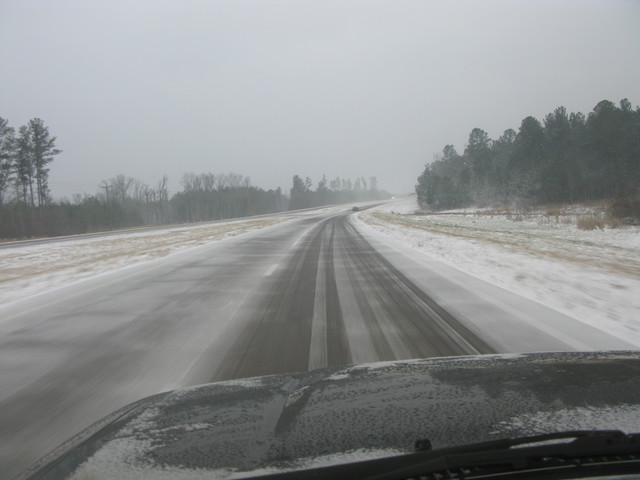
 Provided by David Keeney of Starkville, MS
 Provided by Raimeka Brown of Starkville, MS
 Provided by David Keeney of Starkville, MS
 Provided by David Keeney of Starkville, MS


Sunday, January 9, 2011
2nd Winter Weather Update
~Jackson, MS
10:30p.m.-Heavy snow conditions have fallen in the northern counties above Interstate 20 in which you have all the right type of conditions and temperatures to produce adequate snow. I've already heard reports of 3" inches of snow in Starkville, MS so far. They still have another hour or two to accumulate more.
I don't have an amount yet here around the Jackson area but we only had mixing of snow and sleet which translate to minimal accumulations for some areas and for some more. The dangerous part about it is the accumulation of ice, so again please be careful if you really have to travel tonight.
Winter Weather Update

 http://www.srh.noaa.gov/graphicast.php?site=jan&gc=2, http://www.spc.noaa.gov/products/wwa/, http://www.weather.gov/view/national.php?prodtype=winterstorm
~Jackson, MS
Winter Storm Warning
As you all may have been informed from television as well as from my blog here that we are going to have some significant winter weather on our hands today. A matter of fact only a few hours until those weather conditions enter into the Rankin County area. Even throughout this morning heading to church, I drove through some sleet and I know more will be on the way.
Due to this significant winter weather, the National Weather Service has issued out a Winter Storm Warning. This Winter Storm Warning has been in effect since 9am this morning to 6am Monday morning. This Winter Storm Warning is for all of the central counties and most of the northern counties as well. When a Winter Storm Warning is issued it usually means severe winter weather conditions are expected and significant amount of ice are expected.
Reason for this Winter Storm
A low pressure system will track along the gulf coast to combine with very cold and initially dry air to produce wintry precipitations in the forms of freezing rain, sleet, and snow across northeast LA, southeast AR, and much of Mississippi. Here in MS south of Interstate 20 will see mostly freezing rain and will see mostly ice which is very dangerous considering traveling. Jackson, Brandon, Pearl, Forest, Morton, Newton and many others are including in this. In the Jackson area, we are on that borderline to where we could get alot of snow or just alot of ice. It really all depends but mostly we're looking at freezing rain with mixing snow and sleet. Counties located above Interstate 20 could see anywhere from 4-8 inches of snow especially seeing how the QPF models looked on yesterday.
Preparedness actions/tips
Primary concern right now will be loss of power and telephone service due ice, snow, and gusty winds. So be sure to have a flashlights and extra batteries in case lights do go off. Candles can be used as well but they always carry the risk of fire, so be careful as to where you put your candles. Every home should have this but if you do have a NOAA radio, be sure to have it on especially for emergency reports. Make sure to have extra supples like food and medicines just in case you are not able to go anywhere.
I don't advice anyone to travel especially during tonight but if you do it is still good to encourage in the words of, " Be safe and travel cautiously." You can never hear that enough especially with this type of weather conditions. Also, another tip is to let someone know where and when your have to travel just in case anything goes wrong.
I'll try to have updates later
Friday, January 7, 2011
Friday's forecast for January 7, 2011
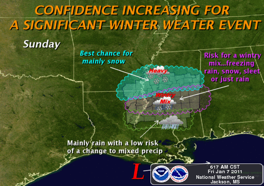 Picture brought to you by the http://www.srh.noaa.gov/graphicast.php?site=jan&gc=1
 ~Jackson, MS
Currently
Hi and welcome to your Friday's Face of the Sky forecast. Another sunny and clear conditions for us once again for our Friday morning. We've been sunny every morning since the beginning of Wednesday and its always a pleasant sight to wake up to sunny skies, although temperatures outside may feel like they are below freezing. Of course, it has not been that cold and we've actually been waking up to temperatures in the upper 30s and lower 40s for the past two days. Currently, temperatures are in upper 40s with windy conditions outside between 10 to 15mph making it feel more like in the lower 40s. Enjoy this bit of sunshine and warmth today as late this weekend conditions will certainly be different.
What's Happening Atmospherically
Alot will be going on this weekend after having relatively quiet weather conditions for the past few days. Lets start with today.
Today
Like I stated previously, please enjoy the sunny and warm conditions today as things are figured get nasty past this weekend. Temperatures should have no problem with reaching the 60s today. So, a pretty decent day but on the windy side however. The reason for the windy conditions we'll have is due to northwest flow aloft at 300mb which is strong and going to help keep conditions both dry and clear along with cold high pressure toward the east. Also, a surface low pressure is going to strengthen as it moves southeast tightening up the pressure gradient giving us these gusty conditions today. We will see gust winds as high as 30mph. By nightfall, we should dive into the mid 30s rather quickly as cold air advection begins to pour in strongly. We are going to retain our clear conditions, with winds not as strong as throughout the day at 5-10mph from the northwest.
Saturday
The high pressure off toward the plain will be moving east and with the cold air advection in place we will be much cooler tomorrow than on today. We may have a chance to touch the 50s but I believe the cold air advection is really going to keep temperatures in the mid to upper 40s. Wind chill factor will be lower.
Sunday
Sunday is by far the most interesting day of the weekend due to wintry weather. The cold air advection from Saturday really sets us up well for Sunday. Okay, there is a low that is going to track into the southeast from the west of the Gulf moving north. This is where we are going to get our moisture from as this system could give us anywhere from a .50 to 1.50 inch of only rain itself. Now, the snow element comes from the cold air advection and a blocking up north set up by a low that is helping to bring cold arctic air surging into the south. This low coming out from the Gulf is forecasted to track further south along the coast of LA and MS, thus helping to increase wintry mix. If it does decide to track further north, then we'll most likely just see alot rain and cold rain that is. However, pretty much all the models agree upon the low being low. Both the Canadian and GFS agree upon the arrival or start of moisture into the MS region by Sunday morning around the time of Sunday School for most churches. By noon, most of the moisture should be in place but I believe most of the wintry mix will start around the mid afternoon into the evening hours. As of right now, I think we'll either start out with sleet or snow. We'll have a little melting starting off first leading me to say sleet starting off with a bit of snow mixing in by nightfall. Our best chance to see snow will be between 9:00 and midnight as conditions begins to get colder and wetter. I don't have good calculations on the snow totals yet because it really all depends still. All of it will be a mixture and so its hard to get totals right now. According to the NWS of Jackson, if the Canadian and European are true in their model forecast we could see anywhere between 4-8inches. If the forecast trends toward the GFS model, then lesser snow totals. So, we'll have some type of wintry weather no doubt but totals right now are a little sketchy. The further north you get, however, a chance to see some decent amount of snow.
Damages
If snow reaches .50 or .75, then we could see broken tree limbs and power line damages. Also, traveling Monday morning will be hazardous due to icy roads. Take care to drive safely and be sure to protect and cover pipes outside pertaining to water. Also, allow your water faucet to drip a little as temperatures will get below freezing for Sunday night into Monday.
Next week
A cold week ahead starting with Sunday night having a wind chill in the mid 20s! No one will probably like Monday as we could stay below freezing for Monday with the wind factor lower than than. Make sure to have your winter clothes set for next week. I'll certainly be back with updates concerning the wintry weather later today or tomorrow. Working overtime for this one! Take care and God bless!
Thursday, January 6, 2011
Thursday's forecast for January 6, 2011
 Picture brought to you by the http://www.weather.com/weather/map/USMS0175?mapdest=US_Weather_Today:SE
 ***To listen to my 30 sec radio podcast, click on this link or copy and paste this to your web browser: http://www.kiwi6.com/file?id=x1v1fo4ew7
Once there you will have to download the file in order to open it.***
Today: High of 57 and sunny; winds northwest at 10 to 15mph
Tonight: Clear and a low of 33; winds west at 5mph
Today: High of 57 and sunny; winds northwest at 10 to 15mph
Tonight: Clear and a low of 33; winds west at 5mph
~Jackson, MS
Currently
A sunny Thursday for you all and I hope everything is going well for you. One more day until Friday! Well, fog conditions quickly dissipated this morning and even the clouds and so we are basically looking at pretty blue skies. Temperatures are in the lower 50s and feeling a little cool especially with winds out of the northwest varying between 5-10 mph. Looks like a sunny day in store for us.
What's Happening Atmospherically
Well, not much too talk about as we will be pretty much on the quiet side of things for a few days. Our next chance to receive any type of rain could be late this upcoming weekend. It feels good to have a break like thsi after having storms after storms come racing in and not to mention severe weather. The reason for the sunny conditions here is because of the high pressure off toward our west. So, as long as it continues to sit around Texas region we will continue to have these sunny and blue skies. Temperatures are still going to be around seasonable around this time of year. I'm looking at mid to upper 50s for highs for the next few days. We will still be kept cool due to strong upper level winds at 300mb. At this height, we do have a jet streak flowing by and some of this flow is mixing down to help sustain our seasonable cool temps.
Next Week
Looking ahead, I do have two things I would like to mention. As of right now, the GFS model shows rain for this upcoming Sunday afternoon. There is not much of an agreement between the GFS and NAM as the NAM shows no rain, so its difficult to pinpoint what time the rain will occur as of right now. Tomorrow, I should have a better handle on it as well as the track of the low will be important. Depending on the low, we could see snow for Sunday. If it tracks further north we will see more rain, but if it tracks further south there will be some chances for snow. Also, I pointed this out yesterday but next week will be cold as Arctic air begins to filter down here to the South. We could see highs possibly next week only in the 30s for mid-week of next week.
Friday's outlook
Friday's outlook
A warm day for Friday as temperatures will be well into the lower 60s. There is nothing like a sunny and warm day on Friday to get the weekend started. Thanks for dropping by for your Face of the Sky forecast and God bless!
Wednesday, January 5, 2011
Wednesday's forecast for January 5, 2011
 Picture brought to you by the http://www.weather.com/weather/map/USMS0175?mapdest=US_Highs_Today:SE
 ***To listen to my 30 sec radio podcast, click on this link or copy and paste this to your web browser: http://www.kiwi6.com/file?id=d3a6yk3ef2
Once there you will have to download the file in order to open it.***
Today: High of 60 with clearer conditions by late afternoon; northwest winds at 5 to 10 mph
Tonight: Cloudy and foggy with a low of 37; north winds at 5 to 10 mph
~Jackson, MS
Currently
Today: High of 60 with clearer conditions by late afternoon; northwest winds at 5 to 10 mph
Tonight: Cloudy and foggy with a low of 37; north winds at 5 to 10 mph
~Jackson, MS
Currently
Goodmorning and welcome to your first Face of the Sky post for 2011! I hope everyone had a great weekend and are having a good week thus far. After I left last week on Friday for Jacksonville, I believe conditions here got pretty severe with reports of a tornado touching down in Pearl and some damages around the Jackson area. I'm glad that everyone around here are safe. By the way, I enjoyed myself in Florida and certainly I would like to congratulate the Bulldawgs on a great Bowl game. They played awesome and the weather there was absolutely perfect. I took some pictures and I'll try to post them when I get a chance.
We are starting our Wednesday morning off with overcast conditions and temperatures are currently in the lower 50s. We will start to warm up a bit after the clouds move off toward the east. We received a bit of rain on last night and the passing showers should be over with by the afternoon.
What's Happening Atmospherically
What's Happening Atmospherically
A weak upper level trough is what is giving us these showers and clouds right now but as it moves further east throughout the afternoon, it will take with it both the showers and clouds. We will start to see clouds clearing out by late this afternoon. After this system, we will remain pretty much on the quiet side of things as temperatures will be around seasonable for the rest of the week and with our next chance of rain coming in on late Saturday night. The controlling factor will be a weak high pressure system off toward the west which will helped to maintain calm and cool conditions for us. Mostly we will see highs in the mid 50s with upper 30s as lows for the most part of the week. The only thing worth noting pretty much today will be fog conditions setting in for tonight. As skies clear out tonight, moist air that is already near the surface will begin to cool and will result in fog formation. In some areas, fog conditions will become dense and will last all the way into Thursday morning. So, if your traveling on the road tonight or heading to work or school in the morning please travel safely as visiblity will be limited.
Today
Today
Overcast conditions throughout the morning and the most part of the afternoon. Conditions should begin to clear off by the late this afternoon with highs into upper 50s. Winds will be coming out of the northwest at 5 to 10 mph.
Tonight
Cloudy but mostly foggy conditions if your traveling. Lows will be in the upper 30s with winds out of the north between 5 to 10 mph.
Tonight
Cloudy but mostly foggy conditions if your traveling. Lows will be in the upper 30s with winds out of the north between 5 to 10 mph.
Thursday's outlook
As you head out for work or school, fog conditions will be dense so drive with caution. You may even want to head out just a little earlier than usual due to others on the road that may drive slower than usual. Other than that, Thursday should be a much drier and brighter day for us with clear skies throughout the afternoon and highs getting into the upper 50s. Looking ahead to next week, we could possibly see some very cold temperatures Wednesday of next week and so I'll keep you inform on that. I hope you all have a great day and God bless!
As you head out for work or school, fog conditions will be dense so drive with caution. You may even want to head out just a little earlier than usual due to others on the road that may drive slower than usual. Other than that, Thursday should be a much drier and brighter day for us with clear skies throughout the afternoon and highs getting into the upper 50s. Looking ahead to next week, we could possibly see some very cold temperatures Wednesday of next week and so I'll keep you inform on that. I hope you all have a great day and God bless!
Subscribe to:
Posts (Atom)
music


