 Picture brought to you by the http://www.srh.noaa.gov/graphicast.php?site=jan&gc=1
 ~Jackson, MS
Currently
Hi and welcome to your Friday's Face of the Sky forecast. Another sunny and clear conditions for us once again for our Friday morning. We've been sunny every morning since the beginning of Wednesday and its always a pleasant sight to wake up to sunny skies, although temperatures outside may feel like they are below freezing. Of course, it has not been that cold and we've actually been waking up to temperatures in the upper 30s and lower 40s for the past two days. Currently, temperatures are in upper 40s with windy conditions outside between 10 to 15mph making it feel more like in the lower 40s. Enjoy this bit of sunshine and warmth today as late this weekend conditions will certainly be different.
What's Happening Atmospherically
Alot will be going on this weekend after having relatively quiet weather conditions for the past few days. Lets start with today.
Today
Like I stated previously, please enjoy the sunny and warm conditions today as things are figured get nasty past this weekend. Temperatures should have no problem with reaching the 60s today. So, a pretty decent day but on the windy side however. The reason for the windy conditions we'll have is due to northwest flow aloft at 300mb which is strong and going to help keep conditions both dry and clear along with cold high pressure toward the east. Also, a surface low pressure is going to strengthen as it moves southeast tightening up the pressure gradient giving us these gusty conditions today. We will see gust winds as high as 30mph. By nightfall, we should dive into the mid 30s rather quickly as cold air advection begins to pour in strongly. We are going to retain our clear conditions, with winds not as strong as throughout the day at 5-10mph from the northwest.
Saturday
The high pressure off toward the plain will be moving east and with the cold air advection in place we will be much cooler tomorrow than on today. We may have a chance to touch the 50s but I believe the cold air advection is really going to keep temperatures in the mid to upper 40s. Wind chill factor will be lower.
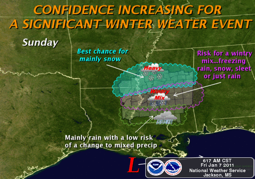
Sunday
Sunday is by far the most interesting day of the weekend due to wintry weather. The cold air advection from Saturday really sets us up well for Sunday. Okay, there is a low that is going to track into the southeast from the west of the Gulf moving north. This is where we are going to get our moisture from as this system could give us anywhere from a .50 to 1.50 inch of only rain itself. Now, the snow element comes from the cold air advection and a blocking up north set up by a low that is helping to bring cold arctic air surging into the south. This low coming out from the Gulf is forecasted to track further south along the coast of LA and MS, thus helping to increase wintry mix. If it does decide to track further north, then we'll most likely just see alot rain and cold rain that is. However, pretty much all the models agree upon the low being low. Both the Canadian and GFS agree upon the arrival or start of moisture into the MS region by Sunday morning around the time of Sunday School for most churches. By noon, most of the moisture should be in place but I believe most of the wintry mix will start around the mid afternoon into the evening hours. As of right now, I think we'll either start out with sleet or snow. We'll have a little melting starting off first leading me to say sleet starting off with a bit of snow mixing in by nightfall. Our best chance to see snow will be between 9:00 and midnight as conditions begins to get colder and wetter. I don't have good calculations on the snow totals yet because it really all depends still. All of it will be a mixture and so its hard to get totals right now. According to the NWS of Jackson, if the Canadian and European are true in their model forecast we could see anywhere between 4-8inches. If the forecast trends toward the GFS model, then lesser snow totals. So, we'll have some type of wintry weather no doubt but totals right now are a little sketchy. The further north you get, however, a chance to see some decent amount of snow.
Damages
If snow reaches .50 or .75, then we could see broken tree limbs and power line damages. Also, traveling Monday morning will be hazardous due to icy roads. Take care to drive safely and be sure to protect and cover pipes outside pertaining to water. Also, allow your water faucet to drip a little as temperatures will get below freezing for Sunday night into Monday.
Next week
A cold week ahead starting with Sunday night having a wind chill in the mid 20s! No one will probably like Monday as we could stay below freezing for Monday with the wind factor lower than than. Make sure to have your winter clothes set for next week. I'll certainly be back with updates concerning the wintry weather later today or tomorrow. Working overtime for this one! Take care and God bless!


No comments:
Post a Comment