Also, be sure to vote on this week's poll question, "Who will win this year's Super Bowl?" It is located on the right side of the page and when you scroll down, it will be under the section Subscribe to my Blog. Support your team!
Today's forecast:
Jackson, MS-------High 38 Low 25
Starkville, MS-----High 40 Low 25
Meridian, MS------High 43 Low 25
Vicksburg, MS-----High 38 Low 23
Greenwood, MS----High 36 Low 20
Tupelo, MS--------High 34 Low 22
Hattiesburg, MS---High 45 Low 27
Pascagoula, MS----High 49 Low 31
~Jackson, MS
Currently~as of 6:20a.m.
Happy Groundhog Day to you and I hope everyone is doing well and staying warm on this cold day. Despite the c
 old air in place this morning, Punxsutawney Phil the groundhog failed to see his shadow this morning. According to folklore, since Phil did not see his shadow then that means an early spring. Otherwise if he did, it would have signified six more weeks of winter. Now, this is all part of folklore and fun and the groundhog has no sort of predictive skills. This has been awhile for now since 1887. We will see later in our to if Phil has any sort of truth in his prediction.
There is also alot of news going on today such as National Signing Day for all the high school players. Elsewhere across the globe, Australia is dealing with a very strong cyclone Yasi, which is now a deadly Category-5 cyclone. Wind gusts of over 180mph with a surface pressure of 942mb!
So, the winter storm here in the U.S. isn't the only type of weather that's going on across the world today. Speaking of the winter storm, it has really brought in cold air into our region dropping temperatures last night into the lower 20s. Brrr! Current temperatures right now are still in the twenties across MS with the wind making conditions feel even colder.
Let's see if Phil knows what he's talking about.
What's Happening Atmospherically
The surface low that brought in precipitation and issued in cold air beh
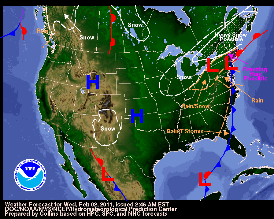 ind it has moved off toward our east and right behind it has settled in high pressure which is allowing for cold arctic air to flow here in the southern region from the north. This 1046mb arctic high pressure located in the Rockies currently will allow for sunshine today, though the day will be highlighted by cold temperatures with an even colder wind chill. There is still a tight gradient between this high pressure and the surface low from yesterday. From these two pressures, strong winds have been induced and is what is causing our wind chill(how the air feels to a person) to be so cool. So even with temperatures struggling to make it into the 40s, it will feel much cooler than that and numbers could be around the lower 30s. We even had reports of strong winds on yesterday according to the Storm Prediction Center. Fifty-three reports or accounts of wind damages on yesterday stretching from east TX to southern AL.
A very brief stretch of sun
 shine today as heavy cloud conditions will begin to move back in tonight and into tomorrow where our next chance of precipitation lies. A closed low from the south will start to stretch northward into MS. For late Thursday afternoon, MS will have rain in its region but only in the southern portion at the time mainly below Interstate 20. It is fairly tough to say if Jackson will be receiving rain at this time as models show that it is borderline with moisture. However, both the GFS, HPC, and Bufkit display the Jackson area and all the northern area finally receiving rain early Friday morning. It will be due because of a surface low which will help to push moisture further north and this should come by either later Thursday night into early Friday morning. Models should be little clearer later today and tomorrow upon the arrival of rain. Just under 0.50 inch of rain here in Jackson and much more in the south.
The main story with this precipition, however, is the chance for wintry mix. Low temperatures will once again fall into below freezing temperatures. This will set us up for a bit of wintry mix. Right now, models are mostly calling for freezing rain. Freezing rain is when rain falls on a freezing surface therefore freezing upon contact. Bufkit shows the atmosphere being to warm to produce any snow especially here in the Jackson area and mainly throughout most of MS. You may see some flurries at time especially with the atmosphere trying to squeeze all the moisture that it has out. Mostly, we'll just have freezing and cold rain. This will make travel conditions dangerous for Friday morning with icy roads, so please
 be careful as you make your morning commute.
Today
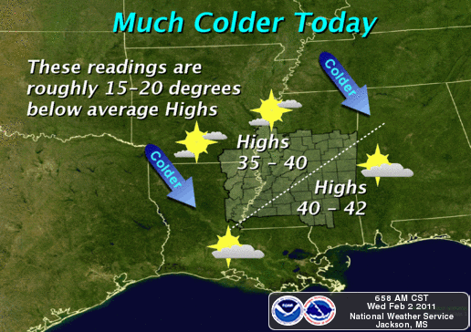
Unlike yesterday, we will see the sun mostly out for today with sunny skies. Temperatures will not be pleasant as highs will be around the upper 30s and lower 40s across MS. Highs will be roughly 15-20 degrees below our average highs. Wind chill could be as low as 20 as winds will be from the northwest at 10 to 13 mph.
Tonight
Temperatures will take another drastic drop as we'll end up around the mid 20s again. More clouds will begin to move into the area with winds of 5 to 10 mph from the northwest.
Thursday's outlook
Throughout the day on Thursday, more clouds will begin progressing into the region ahead of our rain maker for Thursday afternoon. We may start off with light showers through the morning and afternoon hours and by nightfall will switch to heavier rain and freezing rain. Highs in the upper 30s once more.
Long-term
Light rain and moisture should persist throughout Friday and finally leave by Saturday. Cold air will still be around but we do have a chance of warming back up into the 50s by Sunday. As far as Punxsutawney Phil prediction of an early spring, according to ECMWF (European model) next Tuesday night could be our coldest night so far this winter. So our early spring season will have to be put on hold for right now. Prepare for a strong blast of cold arctic air next week.

Stay warm today and enjoy this brief period of sunshine. God bless!


No comments:
Post a Comment