Also, be sure to vote on this week's poll question, "Who will win this year Super Bowl?" It is located on the right side of the page and when you scroll down, it will be under the section Subscribe to my Blog. Support your team!
Today's forecast:
Jackson, MS-------High 70 Low 25
Starkville, MS-----High 67 Low 25
Meridian, MS------High 70 Low 27
Vicksburg, MS-----High 67 Low 25
Greenwood, MS----High 67 Low 25
Tupelo, MS--------High 67 Low 27
Hattiesburg, MS---High 70 Low 27
Pascagoula, MS----High 67 Low 38
~Jackson, MS
Currently~as of 6:30a.m.

On the day before Groundhog Day and on the very first day of February, we are already starting this month out with stormy weather conditions. These weather conditions are not just impacting our state but the majority of the U.S. will be impacted by the same weather system. The impact of a winter blizzard will affect most states while strong winds, thunderstorms, and possible tornadoes could very well impact today's weather here in the south. Right now, we are in the upper 50s and already we having strong winds from the southeast at 15mph. Dewpoints is in the 50s currently. The skies are pretty much covered with both high and thick clouds outside and this is widespread for the state of MS. After today, I don't think Punxsutawney Phil will be calling for spring anytime soon!

What's Happening Atmospherically
Today, we have a huge and potentially a historic winter storm taking place in the Southern Plains. We have an intense weather pattern that consist of two areas of low pressure, one over the High Plains and one over the Souther Plains, and both will converge today over the Central US. It is expected to get stronger as it moves eastwardly especially as strong south winds from the Gulf of Mexico feeds into it adding moisture and also instablity to create stormy conditions here in the Southern region.
For our Day 1 Convective Outlook produce by the SPC(Storm Prediction Center), the SPC have placed a slight risk of severe thunderstorms from east Texas
 across much of lower MS valley. This is mainly due to strong dynamic forcing ahead of this system today. As the cold front makes its way in, southerly low level winds will enhance warm air advection ahead of the cold front. If the right type of conditions emerges and instablity is ripe, then tornadoes will be possible. Please have stay tuned to your local weather news and have your weather radio in hand for any news. Right now, I believe the biggest threat will come from strong gusty winds and heavy rainfall. Close to an inch of rain is expected throughout MS according to HPC. Due to gusty winds, a wind advisory has been issued by the National Weather Service in effect from 9am to midnight of tonight. Its in effect due to southerly winds at 10 to 20 mph increasing throughout the day to speeds of 20 and 30 mph and could gust up to anywhere from 60 to 80 mph at times. This type of wind force can definitely cause significant damages. After the cold front makes its way through, winds will switch from the northwest at 25 to 35 mph into the evening hours. Winds should start to diminish by the overnight hours.
The cold front should make its way in by early noon today from 11am to 2pm and should be around the I-55 corrid
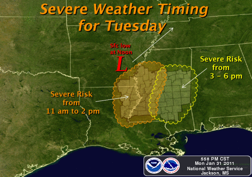 or. From a squall line we will get our chance to see severe thunderstorms and strong winds and then by 3pm to 6pm it should start to deteriorate and makes its way over to our eastern counties. After this cold front passes through, we are going to see an abrupt change in our temperatures as cold arctic air will decrease temperatures from 70 degrees to about 40 in less than 4 hours. By midnight, temperatures will be below freezing. So, winter weather returns back into our forecast with abrupt changes in our temperatures and wind conditions. Look for a much cooler day on Wednesday.
Today
Stormy conditions for today and throughout the MS region. Heavy rainfall, strong gusty winds, and some hail in a few places will be the highlight for today. Also, I can't completely rule out the chances for a tornado even though it is very slim. Please be sure to stay updated with your local weather stations and have your radio in hand for any updates. I am expecting heavy showers to move in right before lunch time and will linger for most of the day. Highs actually will be near 70 degrees but will rapidly drop by nightfall. Winds will be strong at 15 to 25mph. Gusting to 30mph at times.

Tonight
By nightfall, you will definitely and literally feel the difference in temperatures as it will take a 30 to 40 degree plummett rather quickly in just a few hours. By 7pm we will be in mid 50s but by 10pm we will be below freezing at the time. This is just to show you how fast temperatures will drop. Lows across the state will be around the mid 20s. Most of the rain will have cleared out but strong winds will still be very present. Winds will be from the northwest at 15 to 20mph and gusting to 30mph at times.
Wednesday's outlook
Judging from tommorrow outlook, I'll say we'll in for six more weeks of winter as conditions will be very cold. Temperatures will be in the 40s but with strong winds from the northwest at 10 to 15mph, it will feel more like in the 30s.
This is certainly a powerful storm system and will cause damages especially in other states to where this storm is producing blizzards. I will continue to monitor this storm system throughout the afternoon and I'll have detailed reports through the day. So, please keep it here for any updates. Tomorrow, I should have another full report concerning this weather system and its impact not just here but other states. Be safe and God bless!


No comments:
Post a Comment