***If you did not get a chance to see the snow pictures yesterday, you can still view them today.***


Today's forecast:
Jackson, MS-------High 44 Low 21
Starkville, MS-----High 41 Low 22
Meridian, MS------High 45 Low 20
Vicksburg, MS-----High 45 Low 25
Greenwood, MS----High 43 Low 22
Tupelo, MS--------High 41 Low 22
Hattiesburg, MS---High 49 Low 22
Pascagoula, MS----High 52 Low 22
~Jackson, MS
Currently~as of 6:30a.m.

A good Friday to you all and welcome to your weekend Face of the Sky Forecast. I hope all of you stayed warm last night as temperatures drop to record lows this morning across the state. Here in Jackson, our record low for today is 18 degrees and currently we are at 18 degrees now. So basically we are tied and we could dip another degree below to break the record. Elsewhere across the state, other cities have broken the previous low temperature for today with cities such as Greenwood and Meridian. It is very cold throughout MS as temperatures really did plummet downward. We are also still under a hard freeze warning which will remain in effect until eleven this morning. A hard freeze warning means that temperatures will remain well below freezing for a long duration. It is too cold for anybody to be out, so please pray and think about others who don't have a warm home to reside in. Its ironic that we are speaking about temperatures this morning as this will be the continuing theme throughout the weekend.
What's Happening
 Atmospherically
Obviously, the main story for the end of the week is our temperatures. We will go from the lower to mid 40s being our highs today to the mid and upper 60s on Sunday. The setup for all of this is due to high pressure really taking control of the region. This trough of cold air that we have been for the past couple of days will begin to draw back into the north, leaving a ridge of warm air to build across the southern region. As I stated yesterday, we are in a La-Nina pattern which basically means that during this pattern our(south region) winters are usually warmer and drier. Of course, we have been everything less than warm and dry. According to the Madden-Julian Oscillation, blocking in the North Atlantic prevented us from seeing this La-Nina pattern. However, this weekend due to the lack of blocking we will experience a good dose of this La-Nina pattern. This ridge of warm air along with high pressure will continue to build over the weekend and the end result is Spring-like temperatures on Sunday. This will continue into next week as well, although, a cold front will drag through on Monday. This cold front will be very weak and will only slightly decrease temperatures. By Tuesday, southerly flow continues from the south and observing both the GFS and ECMWF(European model), we could see temperatures in the lower 70s by Wednesday. This will mean temperatures will be 5-10 degree higher than normal. The picture t
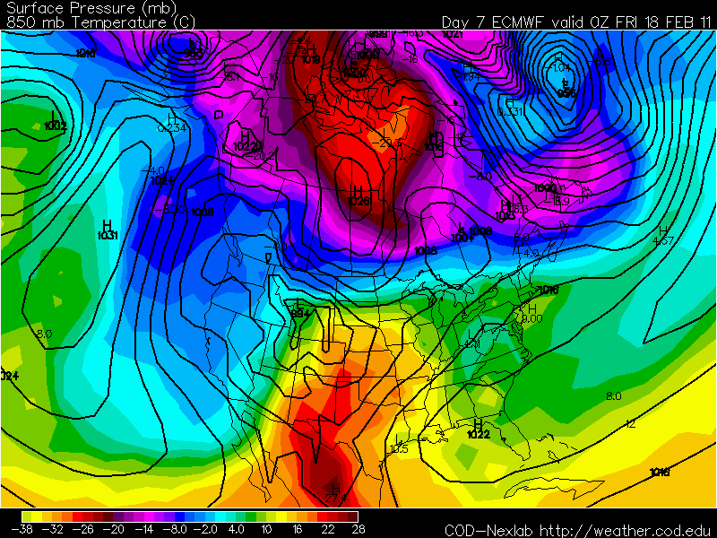 o the right is the European model. Basically, it is displaying warm air advection taking place for next Thursday. We are in the yellow area which has a degree of about 13 degree Celsius which equals to be 55.4 degrees Fahrenheit by 7:00p.m. If temperatures are at 55 degrees by the evening time, you know it has to be warmer earlier in the day, so expecting temperatures close to 70 degrees for Thursday.
Today

We are still going to be cold today but not nearly at the degree we were at yesterday. Temperatures will be about 5-10 degree warmer this afternoon which is a case of sunny skies early this morning as well as cold air subsiding from the area. I think we'll have no problem reaching the mid 40s today accompany by sunny skies. Tonight, lows will drop once again but not at around record lows. Wind will start to come from the west, so not as much cold air pouring in here from the north. Temperatures will be in the low twenties throughout the state.
Saturday

By Saturday afternoon, we will be around our normal highs for this time of year. Clear and sunny conditions will make for a pretty day with temperatures around the mid 50s. Winds will be calm for the most part but then come from the west at 5mph. A warmer night Saturday night compared to the two previous two nights as lows creep into the lower 30s.
Sunday
This will be the best day of the weekend with temperatures in the mid to upper 60s. It is going to be very lovely with nothing but blue clear skies. The best part is that it will continue throughout next week. So a nice little period of plenty of sunshine with no rain forecasted. Sounds like a great weekend to me!
Hope each and every one of you enjoy the weekend and the next pleasant few days. I love snow and winter, but I too am ready for a bit of a warm up. Thank you for viewing your Face of the Sky forecast. Thank you all for the support and the love you show toward me just by taking time out your schedule to visit my blog. It is most certainly appreciated and may God continue to bless all of you! I'll see you all back here next week.


No comments:
Post a Comment