 Picture brought to you by the http://www.srh.noaa.gov/graphicast.php?site=jan&gc=2
To listen to my 30 sec radio podcast, click on this link or copy and paste this to your web browser: http://kiwi6.com/file?id=d0uvr3l8tg
Once there you will have to download the file which is safe to do.
Today: Clear and sunny conditions with a high of 43; winds northeast at 5mph
Tonight: Clear night with a low of 22; calm winds
~Jackson, MS
Currently
A good Monday to you all and welcome to your Monday's edition of your Face of the Sky forecast. I hope everyone enjoyed Christmas on yesterday and received the things you wanted. Even if you didn't, I hope you still enjoyed Christmas realizing that it wasn't about the gifts and presents but it was all about Jesus Christ our Saviour. I certainly had a great time and it was great to see family once again. It's always a blessing to see family and to see them doing well. So this was on Saturday when I visited family and I came back Saturday night. I was back in Jackson on Sunday and what caught my attention as well as everyone elses was snow flurries that occurred Sunday morning and afternoon. It was nothing heavy and it only produced light dusting. However, I did not see snow flurries in the forecast as our best chance for snow flurries were on Saturday. In simplest terms, the reason for the flurries was due to a combination of low level moisture and Arctic cold air in the higher levels. Even though it was dry but cold in the higher levels, we still had a little bit of moisture down at surface levels allowing for light dusting of snow flurries to occur. For the next two or three days, we won't see anymore of these flurries but it will still continue to remain cold here in the South.
What's Happening Atmospherically
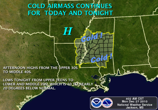
We are still getting some strong cold air advection from the north which is going to maintain the cold conditions for today. The high pressure that is situated in the LA and Arkansas is giving us this nice sunny condition outside. For the rest of the day into tomorrow, we will continue to be under this ridge of high pressure as the cold air advection slowly lifts up out of the area. Even with the high pressure in placed, this cold airmass will continue for today and tonight as temperatures ranges from the upper 30s to middle 40s for our daytime highs and drop to the teens and lower 20s for our lows. We won't be quite as cool tomorrow as temperatures will slowly start to increase throughout the week. This high pressure will continue to keep the southern region dry and I am not expecting any heavy rain until mid-week on Wednesday or so. So, a relatively quiet first-half of the week we have in stored for us. However be on the look-out for stormy weather this weekend moving into our area by Friday. I'll keep you posted.
Today
Today
A few high clouds in the sky but mostly sunny conditions with highs in the lower 40s. Wind chill factor in the upper 30s with winds from the northeast at 5mph.
Tonight
We will remain mainly clear for the rest of the evening into the night hours. A good night to shoot some early fireworks with clear skies on display. That is only if you can bear the cold temps that will be on display as well seeing temperatures in the lower 20s. Wind chill factor will be in the teens with calm winds tonight.
Tuesday's outlook
Look for another cool but yet sunny day tomorrow with slightly warmer temperatures. We may have stormy conditions to spoiled our plans for New Year's, so please keep it here for all your latest updates. I will have more details coming up for your Face of the Sky forecast. Enjoy the day and God bless!


No comments:
Post a Comment